|
|
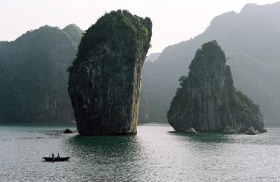
Halong Bay, Vietnam
First came across this place on flickr, somewhere I must definitely visit before I'm 50. I am so going windsurfing here.
A google image search brings up a bunch more pictures.
found at
Created 2005-12-07 18:17:17 by 330 and filed under stuff
Comments 
 |
|
Nguyen Minh Tuan writes...
ABOUT HA LONG BAY
Ha Long Bay, located in the Gulf of Tonkin, includes some 1600 islands and islets forming a spectacular seascape of limestone pillars. Because of their precipitous nature, most of the islands are uninhabited and unaffected by man. The exceptional esthetic values of this site are complimented by its great biological interest. PHYSICAL FEATURES Ha Long is a large bay with a multitude of limestone rocks emerging from the Hon Gai sea, schistic islands from the Cam Pha sea and a limited number of earth islands formed from decayed lateritic mountains. In total, there are 1,600 islands and islets, of which 1,000 have been named. Larger islands, rising to 100-200m, are found in the south, with smaller islets of only 5-10m height interspersed. To the east of the Bay medium size islands feature almost vertical slopes. Numerous caves and grottoes are found, with stalactites and stalagmites. The earth islands are inhabited. VEGETATION There is a diverse flora throughout Ha Long, and primary tropical forest is found, mostly on the islands of Ba Mun and Cat Ba. FAUNA Results from preliminary surveys indicate the presence of about 1,000 fish species. Mammals, reptiles and birds are found on the islands, especially the earth type. CULTURAL HERITAGE Numerous archaeological sites have been found and at Giap Khau (Hon Gai) there is evidence to suggest occupation by the Hoa Binh Culture, some 10,000 years ago present. Archaeological sites at Tuan Chau, Ngoc Vung, Cai Dam, Dong Naim and Cat have revealed so many artifacts that they have been grouped under the term `Ha Long Culture`, typical of the northeastern coast of Viet Nam in the Neolithic Age.During prehistoric times, Ha Long was a significant port, located on the trade routes between China, Japan, and other countries in South East Asia. LOCAL HUMAN POPULATION An unspecified population makes its living in and around Ha Long, which is a major centre for fishing, agriculture and maritime transport. Steps have been taken to open new ports, factories and housing on the shore in line with a long -term economic development programme.
http://www.halongbay-vietnam.com posted: 2006-06-09 05:56:58 |
|
|
|
Nguyen Van Tu writes...
Ha Long Bay is northern Vietnam`s biggest attraction, one of the most magnificent natural splendors of the Far East. ``Ha Long`` means ``Where the Dragon Descends into the Sea.`` From the emerald-green waters of Ha Long Bay some 3000 limestone and dolomite islands (. or ``grottos``) rise jaggedly from the Gulf of Tonkin like medieval stone cathedral spires, or the scales on a dragon`s back. Local lore has it that an enormous dragon created the bay, grottos and outcroppings as it thrashed its way toward the open sea to prevent the intrusion of enemy navies. Today, local fishermen still report encountering a giant sea beast called Tarasque, sort of the Nessie of the South China Sea.
Ha Long Bay affords some of Vietnam`s most spectacular scenery, including beautiful limestone formations, rock arches, gin-clear water, virtually inaccessible lagoons, sheer cliffs, peaceful coves, eerie caves, secluded strips of white, powdery sand, and thousands of limestone islets. Like sculpted cartoon characters, these islets are fancifully named: Frog Island, Face Island, the Isle of Wonders and the Isle of Surprise. Chinese junks glide over the teal-hued bay between the grottos, which are densely carpeted in neon-green ficas, mangrove and spiky cacti. Pearl oyster farms are tucked into tight channels between the towering, limestone cliffs. Primitive floating fish hatcheries are spun across the waters between the grottos like neglected spider webs. This maritime mountain range reaches for a distance of more than 100 kilometers and covers an area of some 1553 square kilometers.
Two major battles were fought in Ha Long Bay during the 10th and 13th centuries. In 1882, French Captain Henri Rivière was beheaded here after trying to capture the region`s enormous coal deposits. The locals paraded his head from village to village. The French weren`t amused, and decided that Vietnam should be permanently annexed as a French colony.
Coal remained the mainstay of local industry until recent years, when hydroelectric projects in both Vietnam and China (where much of the coal was destined) largely relegated it to the proverbial back burner. Locals have diverted their attention from the coal mines to the gold mine of tourism. Nevertheless, coal mining remains an eyesore to the more adventurous travelers who decide to head to Mong Cai in Vietnam`s far northeast.
Ha Long`s only natural drawback is the weather: It can be horrible. It is often damp, rainy and cold, particularly during the winter months. Visitors during the winter tend to spend most of their time in the bay itself, as Ha Long`s waters remain bathtub-warm year-round. If Ha Long were, say, a thousand kilometers closer to the equator, this would be paradise on Earth. As it is, it`s still darn close. Catch the area on a nice day, particularly during the spring and fall months, and you`re in for one of the biggest treats of your Vietnam visit. posted: 2006-12-16 04:53:15 |
|
|
|
Anonymous writes...
Just next to the world famous Ha Long Bay, a world natural heritage, Bai Tu Long Bay is not any the less beautiful with hundreds of islets rising from the clear water and long and smooth sand banks
posted: 2007-04-28 15:52:39 |
|
|
|
Tu Nguyen writes...
Situated in the Tonkin Golf, Halong bay is one of the world's natural wonders - a bay with more than 3,000 islands, which time, wind and waves have sculpted into fantastic shapes. The best way to appreciate this magical scene is from a boat, cruising between these karst cliffs, which loom like fairy-tale castles, complete with rocky spires and hidden caves. The bay is dotted with tiny islands, pristine sandbanks on the turquoise water providing an excellent backdrop for swimming or just lazing about on the junk boat. posted: 2008-10-29 11:25:43 |
|
|
|
hanoipeacetour writes...
Halong City
Area: 208.7 sq. km
Population: 185,228 habitants (year 2001)
Administrative division:
- Wards: Ha Khanh, Ha Lam, Ha Trung, Ha Phong, Ha Tu, Hong Hai, Cao Thang, Cao Xanh, Yet Kieu, Tran Hung Dao, Bach Dang, Hon Gai, Bai Chay, Hong Ha, Ha Khau, Gieng Day, Hung Thang, Tuan Chau
- Communes: Viet Hung, Dai Yen.
Ethnic groups: Mainly the Viet (or Kinh)
Halong City, formerly the Hon Gai Town, is the cultural, economic and political centre of Quang Ninh Province. It borders Cam Pha to the east, the Yen Hung District to the west, the Hoanh Bo District to the north and Halong Bay to the south with the coastline of 20km.
The city is divided into two parts: East Halong and West Halong. The eastern part is an industrial zone where most of the province’s official buildings are also concentrated. The western part, also called Bai Chay, is the animated tourism zone.
Thien Cung Grotto
Halong’s population are most having emigrated from other places to settle here. Halong Bay is famous internationally, and is recognized as a World Heritage by UNESCO for its thousands of natural islands. Also in the city, there are temples, pagodas and historical relics.In addition to the most active branch of tourism, there are other economic activities such as: trade, seaport, coal, marine products and the production of construction materials. Halong Vietnam posted: 2008-12-17 09:53:28 |
|
|
|
deleteme writes...
posted: 2010-01-5 10:24:24 |
 |
|
Haibui writes...
HA LONG BAY VIETNAM
Ha Long Bay, in the Gulf of Tonkin, includes some 1,970 islands and islets, forming a spectacular
seascape of limestone pillars and forested cone-shaped islands. Because of their steepness, most of
the islands are uninhabited and unaffected by humans. The site has outstanding scenic beauty and
great geological and biological interest.
COUNTRY Vietnam
NAME Ha Long Bay
NATURAL WORLD HERITAGE SITE
1994: Inscribed on the World Heritage List under Natural Criterion vii;
2000: Inscription extended under Natural Criterion viii.
IUCN MANAGEMENT CATEGORY
Unassigned
BIOGEOGRAPHICAL PROVINCE
Thailandian Monsoon Forest (4.10.4)
GEOGRAPHICAL LOCATION
A group of offshore islands in the northern Gulf of Tonkin, northeast Vietnam, about 165 km east of
Hanoi between 106°58' to 107°22'E and 20°45' to 20°56'N.
DATES AND HISTORY OF ESTABLISHMENT
1962: Established a Historical & Cultural Relict and National Scenic Spot under Decision No.313/VH
1994: Designated a World Heritage site of 43,400 ha;
2002: Ha Long Bay Heritage Area established by Prime Ministerial Decision 142 TTg (155,300 ha);
2004 Part of adjacent Cat Ba Island designated an MAB Biosphere Reserve (core: 8,500 ha).
LAND TENURE
Government of Vietnam. Managed by the Ha Long Bay Management Department of Ha Long City for
the Quang Ninh Provincial People’s Committee.
AREA
150,000 ha. Adjoined on the west by Cat Ba Island National Park and Biosphere Reserve (26,241
ha).
ALTITUDE
Sea-level to >200m.
PHYSICAL FEATURES
Ha Long Bay is a large bay near the mouth of the Bach Dang river with a mature karst landscape of a
multitude of sparsely tree-clad limestone pinnacles rising from the sea, with islands of schist in the
southeast plus a few more formed from decayed lateritic hills. The surrounding sea is only 6-10m
deep except along old river channels, the result of a marine transgression caused by the sinking of
the underlying limestone plateau. In all, there are 1,969 islands and islets, of which 989 are named. Larger islands, rising to 100-200m, are found in the south, interspersed with smaller islets only 5-10m
high. On the east side of the bay the middle-sized islands have almost vertical sides. The pinnacles
are separate 50-100m towers with a height to width ratio of 6:1 of a classic fenglin landscape form
where the plain from which they rise has been flooded by the sea. There are also rows of cone-
shaped islands characteristic of a fengcong landscape. There are two larger islands and the laterite
islands are inhabited. Adjacent on the west are the similar Cat Ba islands, and on the east, the less
disturbed islands of Bai Tu Long Bay.
The oldest rocks are Ordovician. During the Phanerozoic, terrigenous, volcanogenic and cherty-
carbonate sediments were laid down containing abundant graptolites, brachiopods, fishes, corals,
foraminiferas, radiolarias, bivalves and flora in ten separate layers, from Devonian to Carboniferous
when extensive coal seams were laid down. The limestone karst of the bay developed since the
Miocene. In the Quaternary the rocks underwent five marine and continental intercalations. The
present Ha Long Bay appeared after the maximum transgression in the Middle Holocene, leaving
undercut limestone cliffs 2,280 to >40,000 years old. There are many remnants of old phreatic caves,
old karst foot caves, marine notch caves and several very large caverns: Hang Đầu Gỗ (Wooden
Stakes Cave or Grotte des Merveilles is the largest, and its three large chambers contain many
stalactites and stalagmites. There are numerous lakes which occupy drowned dolines within the
fengcong islands, and springs on the shores of the bay. Geological resources are abundant:
anthracite, lignite, oil shale, petroleum, phosphate, limestone and cement additives, kaolin, silica
sand, dolomite, quartzite, antimony and mercury of hydrothermal origin. (Tran et al., 2000).
CLIMATE
This is an equable warm climate with four distinct seasons, subject to typhoons and tropical storms
from the southeast in autumn. The average annual temperature ranges between 19o
C and 25o
C. The
average annual rainfall is between 1,600mm and 1,800mm, falling from May to September, most
heavily during July and August. Only 150-400mm falls the rest of the year, often as drizzle, but winter
can be cool and very misty. The average relative humidity is 84%. The many islands buffer the waves
so that the seas are usually calm.
VEGETATION
Ha Long Bay contains a diverse ecological system that includes tropical forests, mangrove forests of
20 species, seagrass beds of 5 species and productive coral reefs. Primary tropical forest is found
mostly on the larger islands like Ba Mun, sparsely on the upright limestone islands and thicker on the
less steep schist and laterite islands. A study by the Institute of Ecology and Biological Resources of
Hanoi (IEBR) of the tropical forest ecosystem in Ha Long and neighboring Bai Tu Long Bay recorded
499 limestone-adapted plants including seven new to science. The IEBR study of the wetlands of the
Bay and its surroundings distinguished six sub-ecosystems: tidal and mangrove, tidal flats, caves and
closed lagoons, hard bottom / coral reefs, soft bottom, and aquatic (Halongcruisejunk, 2008). Cat Ba
National Park to the east is on a large well forested island with 800 vascular plant species, 265 of
which are timber trees (sjvietnam 2008). Its primary tropical limestone forest features Spondias
lakonensis, Milius flipes, Indospermum sp., and the mangroves Rhizophora mucronata, Bruguiera
gymnorhiza, Kandelia candel and Aegiceras mafus. Its tidal flats have 75, and its coastal lagoons 21
species of marine algae (UNESCO, 2008).
FAUNA
According to data from the National Conference on the Biodiversity of Ha Long Bay held in late 2003
at Ha Long City the area, which includes the shores of the bay, has a total of 1,847 species and 30
cave/grotto species groups. The IEBR study of the tropical forest ecosystem listed 14 mammals, 40
birds 4 amphibians and 8 reptiles. The 14 mammal species include rhesus monkeys Rhesus mulatta
and long-tailed macaque Macaca fascicularis, also squirrels, weasels, antelopes and iguanas. 60
endemic snails have been found, especially abundant in the caves (Anon.,2004). Almost 1,000
species of fish and marine animals live in the bay. The coral averages 30% cover but is much denser
on eastern and southern coasts. Adjacent Cat Ba National Park has 32 mammal, 79 bird, 30 reptile
and amphibian, 500 mollusc and 400 arthropod species (UNESCO, 2008).
According to the IEBR study, the six aquatic sub-ecosystems of the Bay yield the following species
totals. The tidal and mangrove ecosystem, important as a nursery and shelter, has 91 species of blue
green algae, 169 species of sandworm (polychaetes), 400 species of fish, 200 species of bird and 10
species of reptile. Tidal flats without mangroves typically hold molluscs and sandworms, almost all
overexploited. Caves, reservoirs and closed lakes contain 18 seaweeds, 65 species of coral, and 40 bottom-dwelling species. The hard bottom ecosystem and coral reefs are mostly fringe lagoons, reef
flats, internal and external, crest, slope and platform reefs. It is estimated that there are 232 coral
species, 81 species of snail, 130 molluscs, 57 crabs, 55 sand worms and around 19 newly identified
species of sponge. The soft bottom is a sea-grass ecosystem with 5 species but also includes 141
seaweeds, 29 molluscs, 3 sand worms and 9 crustaceans. The aquatic ecosystem contains rich
reserves of plankton, bottom-dwellers and free-swimming species including 300 mollusc species, 200
sand worms and 13 echinoderms (Halongcruisejunk, 2008).
CULTURAL HERITAGE
Many archaeological sites have been found dated between 25,000 to 3,000 years before the present.
At Giap Khau (Hon Gai) the evidence suggests occupation by the Hoa Binh Culture 10,000 years
ago. Archaeological sites at Tuan Chau, Ngoc Vung, Cai Dam, Dong Naim and Cat Ba have yielded
so many artifacts that they have been grouped as the Ha Long Culture, typical of the northeastern
coast of Neolithic Viet Nam. Ha Long was a significant port, located on the trade routes between
China, Japan, and other southeast Asian countries, and the Bay was the site of three famous battles
against Chinese and Mongol invaders. Many island names derive from their unusual shapes: Voi
(elephant), Ga Choi (fighting cock) and Mai Nha (roof).
LOCAL HUMAN POPULATION
About three hundred people live within the site in floating villages of houseboats and bamboo rafts.
On first designation as a World Heritage Site in 1994, local fishermen were urged to leave their
villages for dry land, but they chose to stay on in their ancestral waters fishing for 200 species of fish
and 450 species of mollusks (sjvietnam,2008). They are now beginning to become more commerce-
and tourism-oriented. The larger islands in the bay such as Cat Ba have permanent inhabitants.
Major shipping routes run straight through the archipelago. The bay is a major centre for fishing,
agriculture and maritime transport and an increasing population makes its living on and around its
coasts which are lined with polluting industrial cities and coal mines which produce most of the
country’s coal. A long-term economic development program proposes new ports, factories and
housing along its shores.
VISITORS AND VISITOR FACILITIES
Ha Long is extremely popular with both Vietnamese and international tourists. During 1998, 300,200
people visited the Bay, 38% being foreigners (Anon, 2004). By 2002 there were 1.7 million annual
visitors (HLBMD, 2003). The numbers are now being controlled. Junk boat tours and cave tours led
by multilingual guides, kayaking, camping and swimming are all very popular. There is an information
Centre at the Ha Long city wharf and an eco-museum and new tourist centres are being built. Tuan
Chau and Cat Ba also have tourist facilities, including hotels and beaches (HLBMD,2004). Some of
the smaller islands have beautiful beaches.
SCIENTIFIC RESEARCH AND FACILITIES
In 1998 the area’s geomorphology was studied, resource use has been mapped by a Belgian team, a
guide to the plant species completed by a team from the Netherlands in 2000, the extent of pollution
measured by the Japanese International Cooperative Agency, and the area’s ecosystem and
biodiversity studied by the Korean Institute of Ecology and Biological Resources. The IEBR has
catalogued the ecosystems and species of the area. The Free University of Brussels and the Vietnam
University of Natural Sciences developed a GIS database for the province. The Park Authority
monitors coral reefs, the use and management of mangroves and surrounding land uses.
(Anon.,2004). Monitoring of water quality and quantity and of biodiversity is done by the Quang Ninh
Department of Science and the Institute of Oeanography at Hai Phong (HLBMD, 2004).
CONSERVATION VALUE
The Bay is a spectacular seascape of pristine limestone pillars and islands The site also has much
geological, archaeological and biological interest, especially for marine species. The Park lies within
a Conservation International-designated Conservation Hotspot and a WWF Global 200 Eco-region.
CONSERVATION MANAGEMENT
The Ministry of Culture, Information & Sports is responsible for the overall management of the Bay,
under the People's Committee of Quang Ninh Province which is responsible for the administration
and management of territory within its jurisdiction. Despite the intensive development in the region,
Ha Long Bay itself is being protected as a major tourist and cultural centre and the impacts of cave-
tourism and urban waste are being brought under control. From 2005-8 a successful community education program was run by Fauna and Flora International (HLBMD, 2004). The Bay is one of the
23 parks in the ASEAN Heritage Parks Program.
MANAGEMENT CONSTRAINTS
Ha Long Bay needs much preservation and protection, from the authorities as much as from local
people and burgeoning tourism. The delicate limestone cave ecosystems are being degraded as
tourists break off stalagmites and stalactites and drop litter like wine bottles into cave streams. The
mouths of some caves have been widened to allow tourist access and the increase in light and
disturbance has led to imbalance in the delicate links between the flora and fauna, to decreasing
humidity inside the caves and increasing carbon dioxide which accelerates the growth of algae. With
a booming tourist trade, mangroves and sea grass beds have been dredged and jetties and wharves
built for tourist boats. Heavy metals, fuel and oil, along with tourist garbage, have polluted the islands
and their waters which have become turbid. Human waste from portable toilets for tourists seeps into
the soil and waters around the islands, altering the ecosystems through nutrient enrichment. Game
fishing, often near coral reefs, threatens many endangered species which are often not eaten locally
but exported to other markets around the region (sjvietnam, 2008). Coral is sold as trinkets by the
locals but despoiling it expels the fish that they depend upon for their survival.
Efforts to protect this fragile ecosystem have now been made and a Sea Rescue Centre has been set
up to address the dangers. But three potential threats remain: the pressure on natural resources from
the growth of the urban population and industries such as coal mining; expanding aquaculture; and a
proposed new port that would draw larger transport ships through the islands (HLBMD, 2004),
increasing the risk of spills.
STAFF
In 2003 there were 226 staff in inspection, accounting and tourism. Even this number was not
considered adequate and more professionally trained staff were needed (HLBMD,2003).
BUDGET
The national government provides a budget to the provincial People's Committee. The income from
entry fees in 2001 was US$1,520,000 but together these were still inadequate to support the Park.
Between 1997 and 2000, WHF provided US$37,235 in project grants. Project assistance has also
come from China, Australia and Thailand. UNDP and BP (via Fauna and Flora International) granted
US$400,000 towards the community awareness program (HLBMD, 2003).
LOCAL ADDRESSES
Ha Long Bay Management Department, 166 Le Tyhanh Tong Road, Ha Long City, Quang Ninh
Province,
Ministry of Culture, Information and Sport, 51-53 Ngo Quyen Street, Hanoi, Vietnam.
REFERENCES
The principal source for the above information was the original nomination for World Heritage status.
Anon. (2004). Cac Dao Vinh Ha Long Cultural and Historical Site. In Sourcebook of Existing and
Proposed Protected Areas in Vietnam.
Deharveng, L. (1998) Ha Long Bay Biodiversity Survey, Cave Fauna. (Unpublished report).
Glover, I. & Ha H-N. (1998). Assessment of the Archaeological Resources of the World Heritage Site
at Ha Long Bay, Quang Ninh Province, Vietnam. Report to the Institute of Archaeology, University
College London and the Institute of Archaeology, Hanoi. (Unpublished)
Ha Long Bay Management Department of Ha Long City (HLBMD) (2003). State of the World Heritage
in the Asia-Pacific Region. Vietnam. Ha Long Bay. Report to the UNESCO World Heritage
Committee, Paris.
Halongcruisejunk.com/travel_guide_detail/ (2008).The Biodiversity Value of Ha Long Bay.
Ministry of Culture, Information & Sports (1992). Nomination of Ha Long - Vietnam. 6 pp.
Unpublished.
KNCCN, IEBR & HNU (1997) Ecosystem and Biodiversity of Cat Ba National Park and Ha Long Bay,
Vietnam. Seoul: The Korean National Council for Conservation of Nature, the Institute of Ecology
and Biological Resources, Hanoi, and Hanoi National University.
Nguyen T-H, Kiew, R. & Gibbs, W. (2000). Wild Plants of Ha Long Bay. Thanh Nhien Publishing,
Hanoi.
Solidarité Jeunesse Vietnam (sjvietnam) (2008). Ha Long Bay. www.sjvietnam.org.
Tran V- T.,Tran S-T.,Waltham, T.,Li S-A. & LaI H-A.(2004).The Ha Long Bay World Heritage:
Outstanding Geological Values. National Committee for ICCP, Vietnam
UNESCO MAB (2004) Biosphere Reserve Information. Viet Nam Cat Ba. Paris
Waltham, T. (1998) Limestone Karst of Ha Long Bay, Vietnam: An Assessment of the Karst
Geomorphology of the World Heritage Site. Report to Nottingham Trent University. (Unpublished)
DATE February 1993. Updated 1-1996, 12-1998, December 2008.
added by a spambodt, oddly enough posted: 2010-05-10 19:13:19 |
|
|
|
Anonymous writes...
That's good that people are able to receive the credit loans and this opens new chances. posted: 2010-07-15 21:30:02 |
|
|
|
Anonymous writes...
I took 1 st credit loans when I was 32 and it aided my business very much. However, I need the credit loan also. posted: 2010-11-24 18:50:34 |
Add Comment
Subscribe to this blog by RSS.
|
|

|
|